

In the southern region of the Great Alpine National Park lies Lake Tali Karng, Victoria’s only deep mountain lake reaching depths of 51 metres. It’s a fairly young lake, having formed a mere 1500 years ago by a landslide that dammed the Wellington River. The lake is sacred to the traditional owners of the area; the Gunai Kurnai people and Aboriginal peoples are not allowed to visit according to lore. However, the Gunai Kurnai do allow non-indigenous Australians to enjoy one of Victoria’s most acclaimed bush walks.
It’s quite a drive to get there from the inner northern suburbs of Melbourne, so we decided to take the extended Australia Day four-day weekend to hike to both the lake and the Sentinels: the nearly 1500-metre high peak overlooking the lake. From Licola, which is about three hours, it’s another 60 kilometres uphill to the start of the track. A through-walk is also possible but requires a car shuffle from the carpark on the Wellington River outside of Licola.
As the Gunai Kurnai elders ask that visitors respect the lake by not camping on its banks, Parks Victoria maintain a basic campground on the Wellington Plain. From the carpark at McFarlane’s Saddle to Nyimba campground it is a good two-hour pack hike. Once there, it is easiest to use Nyimba as a base and do several day hikes from there.
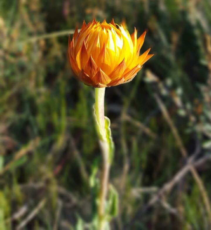
The Wellington Plain track leading to Nyimba is fantastic in a Lord of the Rings kind of way: softly rolling hills form a wide plain interspersed with pockets of snow gums. In summer, white, yellow and purple alpine wildflowers like everlastings (from the genus Xerochrysum), snow gentians (Gentianella diemensis) and grass trigger plants (Stylidium graminifolium) form a stark contrast with the deep, earthy tones of the tough heathland shrubs. I would not be surprised to see a group of Riders of Rohan gallop their horses over the hill at any moment. Good thing they only live in Middle Earth, because about 1.5 kilometres in we pass an information sign by Parks Victoria, describing the small pocket of endangered peat land we are traversing. Feral deer are the largest threat to this alpine sphagnum bog, with bushfires and humans close on their heels. We make sure we stick to the well-worn narrow track after this.
At this subalpine altitude, giant clouds of mist roll in as fast as they make way for blue skies. I can’t decide which version of the plains I like best. It is all so wide and spacious here, the elements unforgiving in their extremes. I wonder to myself what the place looks like in winter, covered in snow.
Nyimba campground has many scattered camping spots, sheltered between stands of snow gums and low bush. There is one pit toilet (bring paper) that catches rainwater from its roof into a 600-litre water tank with a tap. The water tastes beautiful. I swirl it around in my mouth before I swallow, enjoying the softness of it and the lack of added chlorine. When we get back to our spot, two ravens have already been in our food. Several bags lay scattered around the meadow, blatantly ripped from our packs. When the birds see us, they quickly fly up into a dead tree, looking down on us with their dark, beady eyes and calling a disinterested ‘waa’. I realise that they are only babies. Tsk, so young and already thieving.
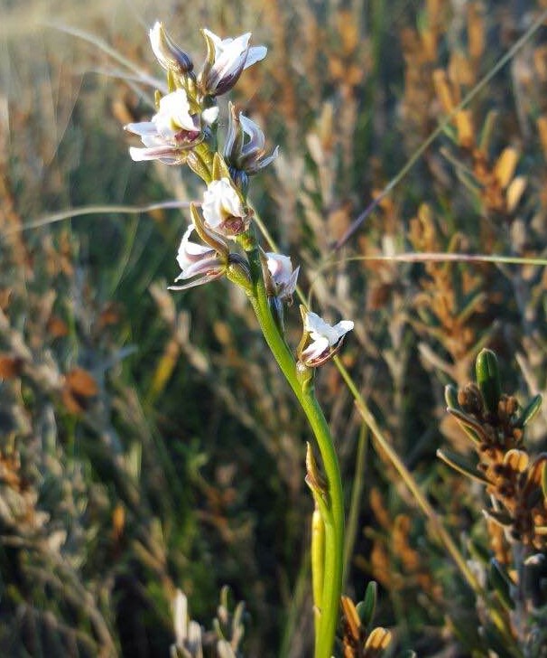
After setting up camp, we relax and I go exploring. Right next to one of the tracks I find a small stand of mauve leek orchids (Prasophyllum suttonii). They are only one of many species of colourful flowering plants. I love how plants of the High Country bloom so late in the year. While Melbourne is sweltering, we are experiencing a second spring up here, flowers and all. For about an hour, I share a sit spot with a fat water skink. Gang-gang cockatoos and rosellas fly around, calling loudly to each other and finding roosting trees for the night.
After a spectacular sunset, all goes quiet – dead quiet. As a matter of fact, I don’t think I’ve ever been anywhere not subterranean where it was this quiet. In the night, I briefly hear the heavy footfall of two wombats gallivanting through the campground, but that’s it. No crickets, no bats, no wind, no humans. I sleep better than I have in a long time.
The morning is stunning with bright sunshine, blue skies and the temperature rising quickly. We can see the mists swirling in the valley beyond Nyimba, but they don’t ever reach the camp. We pack a lunch, bathers and water and start the hike down to Lake Tali Karng.
We choose Gillios Walking Track to go down to the lake, with the intention of looping back up via Echo Point Track. Gillios Track is very steep, but with hiking poles and only daypacks, we manage to get to the lake in about two hours. The track runs through beautiful forests with tall eucalypts and bushy undergrowth, under fallen logs and through thick, prickly shrubs at times. The calls of eastern whipbirds accompany us on the way down. At one stage I climb over a dead tree, trip and nearly land face-first in a patch of Dianella. At least I think it is. This plant resembles a flax lily, with its long green leaves sprouting from the ground. It has long since flowered and is now sporting huge purple berries, whose weight bends the stalks downward. They are bigger than I’ve ever seen on any flax lily and their purple colour is so intense that it almost appears fake. I wonder if they are usable as a fabric dye and squash one between my fingers. A jet of sap squirts onto my shirt, staining it purple. I guess that means yes.
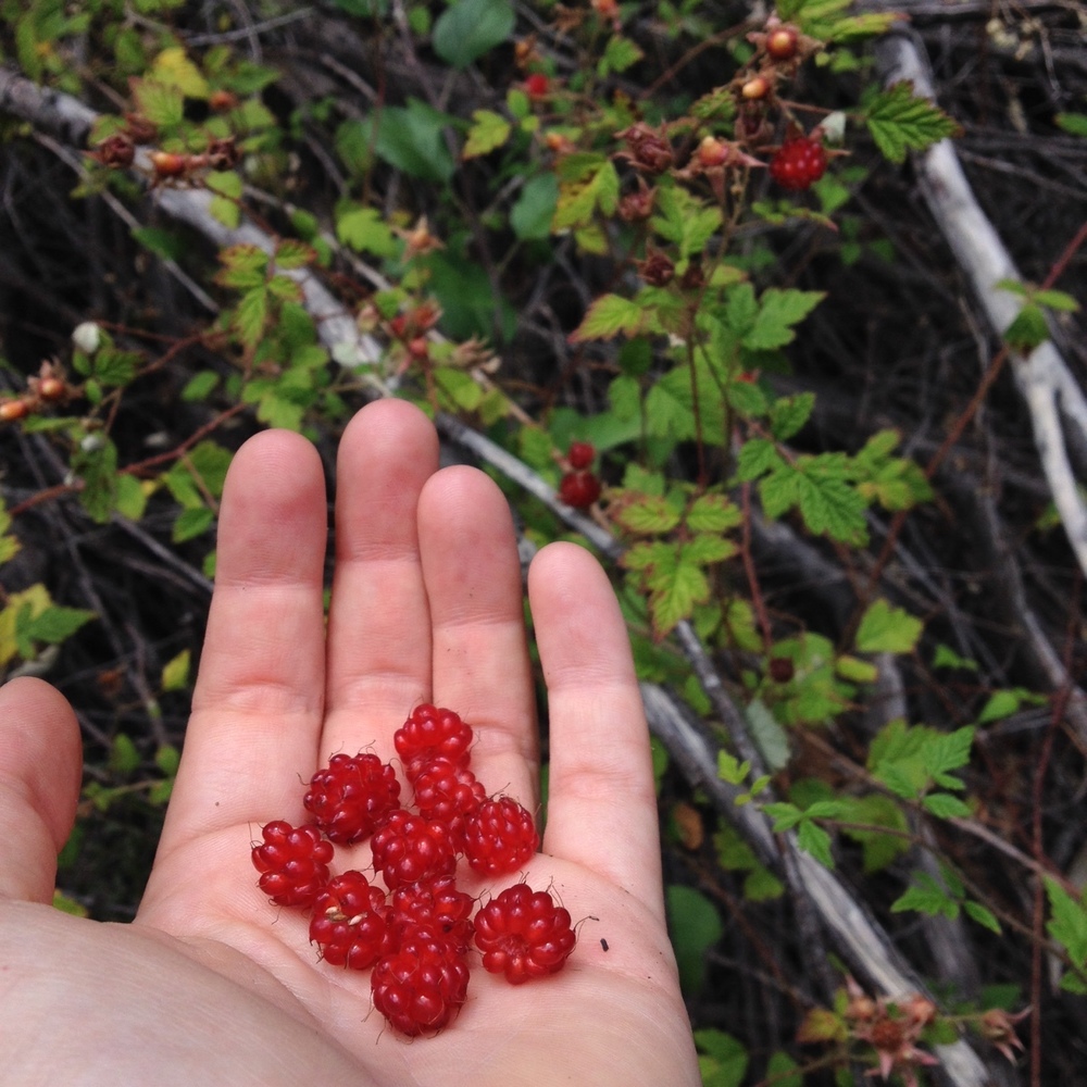
We can see the effects of recent bushfires clearly as we descend, particularly by the new stands of young wattles that surround the lake. As the water of Tali Karng emerges between the trees, we walk a little faster. It looks so good; we can’t wait to cool off with a swim. Down at the lake the area is quiet. I see a few cormorants chase each other over the water on the other side as I strip down and plunge into the cool water. As the waters are slightly acidic, there are no plants or even algae growing in the lake. It looks clear as glass, just as you would expect a mountain lake to look. One of the other hikers we encounter says that he came here 20 years ago and pulled a few big trout out of the water. We keep half an eye out while we circumvent the lake, but no sign of any fish. What we do find however, as we hike to the waterfalls, are many stands of native raspberries (Rubus parvifolius). I can’t believe my luck! Within minutes I have fallen behind, as I’m too busy stuffing my face with shiny red berries to keep up. They taste so refreshingly tart and sweet at the same time that I pity the hikers who have gone before us today, passing the thickets obliviously. Feeling slightly disappointed that I can’t eat them all, I catch up with my partner at the start of Nigothoruk Creek.
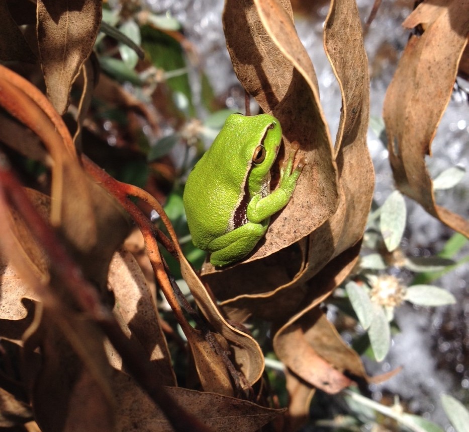
In summer, with the water levels fallen to a minimum, it’s an easy hike to the first set of falls through the creek without getting wet feet. The waterfalls are larger than I expected and surprisingly pretty. We climb up to the first platform and I find my highlight of the trip: a leaf green river tree frog (Litoria nudidigita), trying to camouflage its bright green body by sitting on a brown gum leaf. One can only hope it won’t make that mistake when predators are around. On the bright side, had it not been colourblind, I would probably never have seen it.
After lunch we hike back up the mountain via Echo Point Track. The track climbs so steeply that in the hot weather I have to stop frequently to drink and catch my breath so I can complain about my lack of fitness. I check my GPS and we are moving at the staggering rate of 0.5 kilometres per hour, climbing all of 600 metres. It seems to take forever.
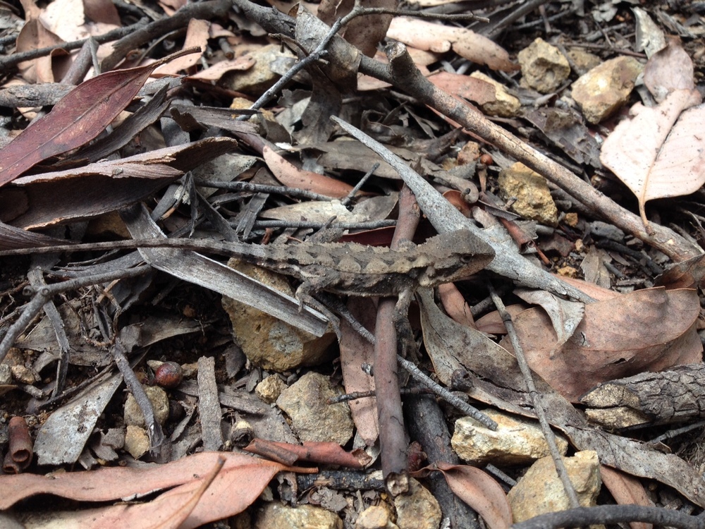
Fortunately, our animal friends are never far away and we see lots of wildlife on this stretch. Tiny, dark brown skinks scatter the leaves in front of our feet as they run to safety and we see several mountain dragons (Rankinia diemensis) camouflaged on the brown leaf litter. My favourite by a mile has to be the mountain bush-cricket (Acripeza reticulata), or, as my friend so eloquently puts it: ‘camo on the outside, disco on the inside’. The females are a mottled brown, but when disturbed they lift their wing covers and flash you with incredibly colourful black, red and blue bands.
As we are nearing the top, the mists roll up the hill behind us, enveloping the campground throughout the night. That night we sleep like we are comatose.
The next morning, we wake up in a cloud. Everything is grey and damp as we eat our breakfast, but the scenery remains beautiful. All is perfectly still when we hoist our daypacks on and set off to the Sentinels. My calves are screaming from yesterday’s exploits as I walk down the hill on Miller’s Hut Track. It sure takes a while to warm up the legs. The Suffering of aches and pains is made up for by the beauty of the trail: massive eucalyptus trees loom up out of the mists, gnarled branches outstretched like those of angry Ents. Some have hollows that look like eyes, following us as we make our way through the forest.
Past Miller’s Hut the track starts to climb slightly. We follow Mount Wellington Track, which is also meant for 4WDs, south to the Sentinels. The whole walk is about six kilometres over a gentle gradient – at no point as taxing as Echo Point Track. Gradually, the tall trees make way for stunted snow gums and the sun breaks through the clouds, dissolving the last of the mists and drying our packs and jackets. Bird life here is abundant, with rosellas, gang-gang cockatoos, grey fantails and pairs of flame robins all around.
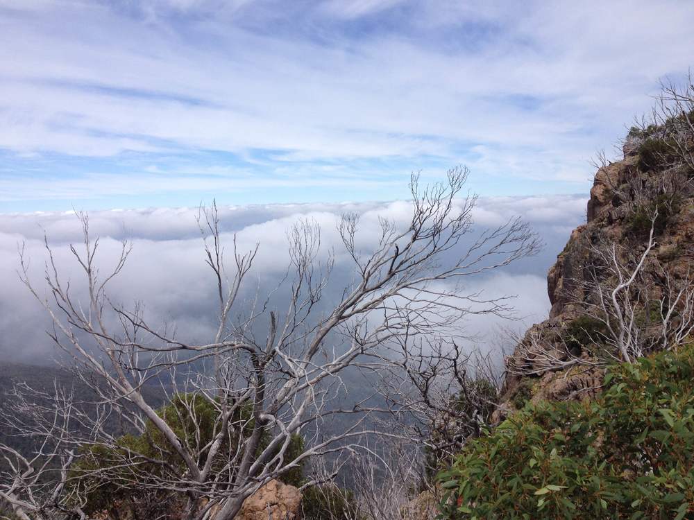
Then it is time for a rock scrambling session up to the top of the Sentinels at 1500 metres. The effort is rewarded with a stunning view of the mountains, looking down on the clouds as if we were flying in an airplane. The winds blow the cloud cover in and out of the valleys below at great speed. The only thing we have to do is sit on a rock overhang, relax and eat our lunch while we watch the scenery change every two minutes. We can see Tali Karng far beneath us, and notice a faraway waterfall cascading down the mountains, feeding the Nigothoruk Creek. It is a beautiful place to rest for a while. We spot many different species of butterfly and even an unidentified, small bird of prey flying below us.
I find there is a great sense of satisfaction in reaching the top of a mountain and seeing the world from above. Looking down on the tops of the clouds and the backs of flying raptors instead of gazing up at them from below shows us that everything is relative. We sit there for quite a while in the bright sun, a cool breeze coming up from the valley below, ruffling our shirts.
On the way back it’s mostly an easy downhill stroll. The mists have disappeared completely, giving us a better view of the stunning old eucalyptus forest surrounding Miller’s Hut. That part of today’s hike is definitely my favourite.
Back at camp, the sun is shining and we find everything has dried out. Still energised from the walk, we decide not to stay another night, but to pack up camp and hike the two hours back to the car. It proves to be a questionable move. You don’t realise how tired you are until you’re battling through the shrub in the heat with a full pack on and the beginnings of a blister on each sweaty little toe – thank goodness the Wellington Plains are flat.
Two and a half hours later we arrive at the car park, drenched in sweat and a little crispy from the sun, but feeling intensely satisfied. We realise that we walked about 24 kilometres that day. Not a bad effort, but in hindsight it would have been better to stay another night and go back the next day.
Summary:
– Camp at Nyimba and do day trips from there.
– Bring a daypack
– Some sections are very steep
– Take at least three, but better four days.
Difficulty

Accessibility
Wildlife

Scenery
Overall
Banner image courtesy of Fam Charko.
Leave a Reply